Biking
Mt Tam State Park Official Bicycle Rules
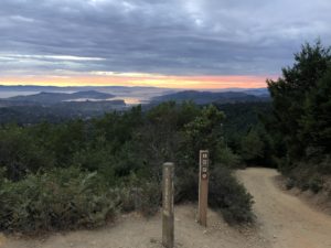
Road cycling and mountain biking are popular activities on Mt. Tam.
Within State Park boundaries, bicycles are only allowed on paved roads, fire roads, and four (4) posted single track trails.
| TYPE | ROAD/TRAIL NAMES |
|---|---|
| Paved Roads |
|
| Fire Roads |
|
| Trails (single-track) |
|
Additional Opportunities
Information about trails found outside of State Park boundariesThe following trails are either found or have some sections that are found outside of the State Park boundaries.
These additional mountain bike opportunities exist by connecting into trails in the Marin Municipal Water District (MMWD), Muir Woods National Monument, Golden Gate National Recreation Area (GGNRA), and Marin Country Open Space District (MCOSD).
The best map to use across all these jurisdictions is Marin Bicycle Map, created by the Marin County Bicycle Coalition (available at the East Peak Visitor Center or online).
Please check the rules and regulations for each district before visiting.
| DISTRICT | ROAD/TRAIL NAMES |
|---|---|
| Within MMWD |
|
| Within GGNRA |
|
| Within Muir Woods National Monument |
|
FMT's Favorite Mountain Bike Rides
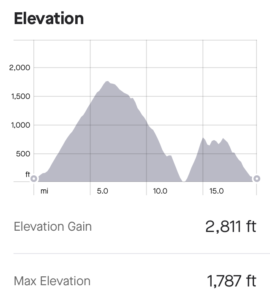
Tour of Mt Tam South Side
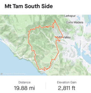
| Highlights |
|
| Distance | 20 miles |
| Elevation Gain | 2,800ft |
| Time | 2.5-4 hours |
| Directions |
|
Pantoll to East Peak Climb
| Highlights | All fire roads (easy grade), West Point Inn, and East Peak Visitor Center. |
| Distance | 3.6mi (one way) |
| Elevation Gain | 860ft |
| Time | 45min-1.5hrs |
| Directions |
|
Tour of Mt Tam North Side
| Highlights | Rock Spring, coastal views, Laurel Dell, Barth’s Retreat, and Potrero Meadow. |
| Distance | 5mi |
| Elevation Gain | 600ft |
| Time | 45min-1.5hrs |
| Directions |
|