Planning Your Visit
General Park Information
Please visit the official Mt Tamlpais State Park website for complete up-to-date information.
Call the Pantoll Kiosk with any questions at 415-388-2070 or email us at friendsofmttam@gmail.com.


Hours:
The park is open daily at 7am until sunset. Cars parked after hours are subject to fines.
The East Peak Visitor Center and Gravity Car Barn Museum are generally open weekends from 12pm to 4pm. Please note the both are staffed by volunteers and hours are subject to change. East Peak can be reached by either hiking, biking, or driving to the top. West Peak is only accessible via hiking.
Fees:
Parking at the Bootjack, Pantoll, and East Peak parking lots is $8, ($7 for seniors). Pantoll accepts credit card during business hours (generally 9am-4pm), all others can be paid by scanning the QR code at the parking site via https://go.lazparking.com/ when you arrive, otherwise they are CASH ONLY so bring exact change.
Walk-in campsites at Pantoll and Bootjack campgrounds are first-come, first-served $25 ($23 for seniors). We recommend bringing exact change.
Reservable campsites/cabins at Steep Ravine, Alice Eastwood, and Frank Valley must be reserved in advance at reservecalifornia.com
Special Events and Group Use fees vary according to the space reserved and the use. For weddings, athletic events, film and photography permits please contact dkopler@parks.ca.gov.
Accessibility:
Campsites, picnic sites, and designated scenic trails in Mt. Tam are accessible (Verna Dunshee, Lower Old Mine, and the McKennan Gulch Trail). For full information, see the State Parks Accessibility website.
Pets in the Park:
To protect wildlife and respect other visitors, pets (except for service animals) are only allowed on paved roads, Old Stage Fire Rd, Verna Dunshee Trail, and in developed areas such as campgrounds and picnic areas. Pets must remain on leash at all times. Pets are not allowed on any trails, dirt roads, and backcountry areas in the State Park.
If you want to bring your dog on a hike with you on the mountain, we recommend visiting the many trails in the Marin Municipal Water District. You may start at Pantoll Station and take the Old Stage Fire Road to get to MMWD trails.
Weather:
The most accurate weather forecast is available through weather.gov.
Visit the National Weather Service website for Red Flag updates that affect Mt. Tam park closures.
Maps & Directions
Trail Maps:
- Downloadable Mount Tamalpais State Park Brochure PDF.
- FMT Trailheads.
To purchase a trail map by mail, send a check for $1.00 made out to Friends of Mt Tam, along with a self-addressed and stamped #10 envelope (4 1/8″ x 9.5″) to:
Friends of Mt Tam
P.O. Box 7064
Corte Madera, CA 94976
Directions By Car:
From Highway 101 take the Stinson Beach exit and follow the signs along Highway 1 up the mountain.
Pantoll Station is located at:
3801 Panoramic Highway
Mill Valley, CA 94941
Directions By Bus:
Mt. Tam is accessible by riding the West Marin Stage Coach (#61). For schedules and stop information, call the West Marin Stage Coach @ 415.526.3239 or visit Marin Transit.
Other:
To combine a tour of Muir Woods National Monument followed by a hike up the adjacent Trails of Mt. Tamalpais State Park, we recommend visiting the Muir Woods Shuttle website. To get to the shuttle stop, Golden Gate Transit operates bus service between Marin City and Manzanita Park and Ride on weekends / holidays between Memorial Day and Labor Day.
Private tour companies also bring groups to Muir Woods on a daily basis. Most tours originate in downtown San Francisco or Fishermans’ Wharf, and include time in Sausalito.


History and Resources
About the Park:
ACREAGE: 6,300 acres
VISITATION: 564,000 visitors in FY 2003
EMPLOYEES: Mount Tamalpais State Park is managed by California State Parks rangers and maintenance staff, and supported by many volunteers and interpretive docents.
HISTORY: Though many believe that the 2,571-foot peak is the remains of an extinct volcano, geologists have decided that Mt. Tamalpais was created by the process of buckling and folding within the earth’s crust. The San Andreas Fault lies offshore to the west, marking the division between two large pieces of the Earth’s crust: the North American Plate and the Pacific plate. The Pacific plate is moving eastward and down under the North American plate, thus uplifting Mt. Tam and the Coast Range.
Natural & Cultural Resources:
NATURAL RESOURCES: Home to several rock-types; sandstone (graywacke), shale, greenstone, chert, quartz, tourmaline, and the green serpentine, which is the state rock of California. Mt. Tam is also a host to a number of plants; more than 750 species, including both the Coast Redwood and the delicate Calypso Orchid, Oak, Chaparral, Douglas Fir and California Laurel Tan Oak. Mt. Tam’s hillsides are sprinkled with California poppies, many species of lupine, all shades of Douglas iris, blue-eyed grass, goldfields, shooting stars, spotted coral root, fetid adder’s tongue, Pacific trillium. Home to many animals; raccoons, gray foxes, squirrels, bobcats, coyotes, mountain lions, and black-tailed deer. Red-tailed hawks, turkey vultures, great horned, spotted, barn and screech owls, woodpeckers, Stellar’s jays and black ravens.
CULTURAL RESOURCES: The Mt. Tamalpais Scenic Railroad was completed in 1896 and ran from Mill Valley to the East Peak summit. A hotel, restaurant, and dance hall followed shortly to make Mt. Tam a popular destination around the turn of the century until 1930, when automobiles became the favored mode of transportation. Called the “Crookedest Railroad in the World‚” the ride up the mountain was only surpassed by the ride down the mountain in a Gravity Car. These 30-passenger cars had only a brakeman to control the roller-coaster descent back to Mill Valley or Muir Woods.
RECREATIONAL RESOURCES: Within the park, more than sixty miles of trails meander through the Park’s landscape and connect with a 200 mile trail network through adjacent public lands. The 3500 seat Cushing Memorial Theater, 2,000 feet above San Francisco Bay, has been the site of the annual Mountain Play since 1913. Group camping is available at Alice Eastwood Group Camp and the Frank Valley Horse Camp. Adjacent to the Pantoll Ranger Station are 16 individual walk-in campsites (available on a first come first serve basis) as well as 15 walk-in campsites at Bootjack. The beautiful Steep Ravine area, located on a rocky headland two miles south of Stinson Beach, offers primitive overnight camping. There are six environmental campsites and ten rustic cabins. Steep Ravine is a very popular campground and reservations are required (Note that Steep Ravine is listed under Environmental Camping for Mt. Tamalpais, when you call Reserve California).
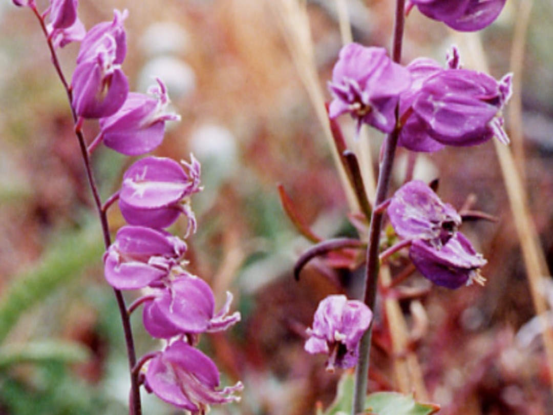
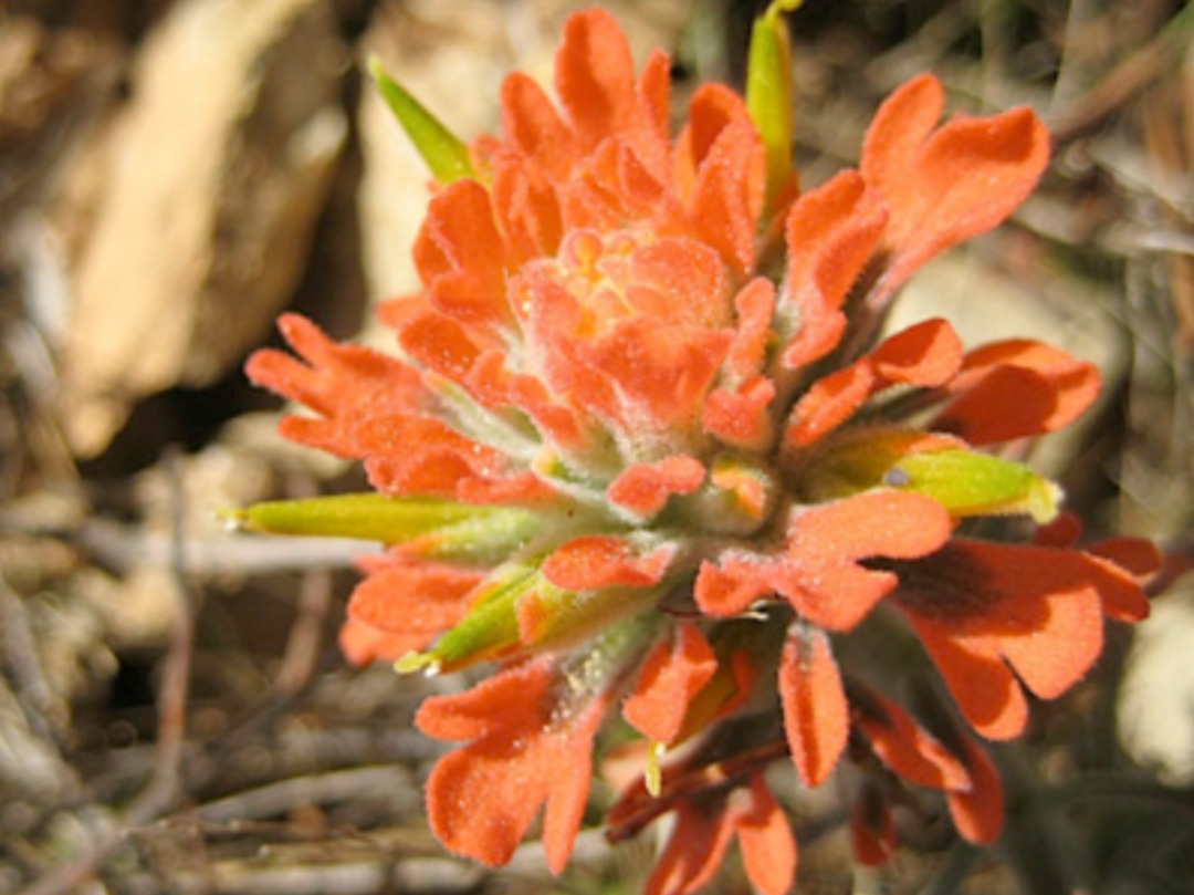
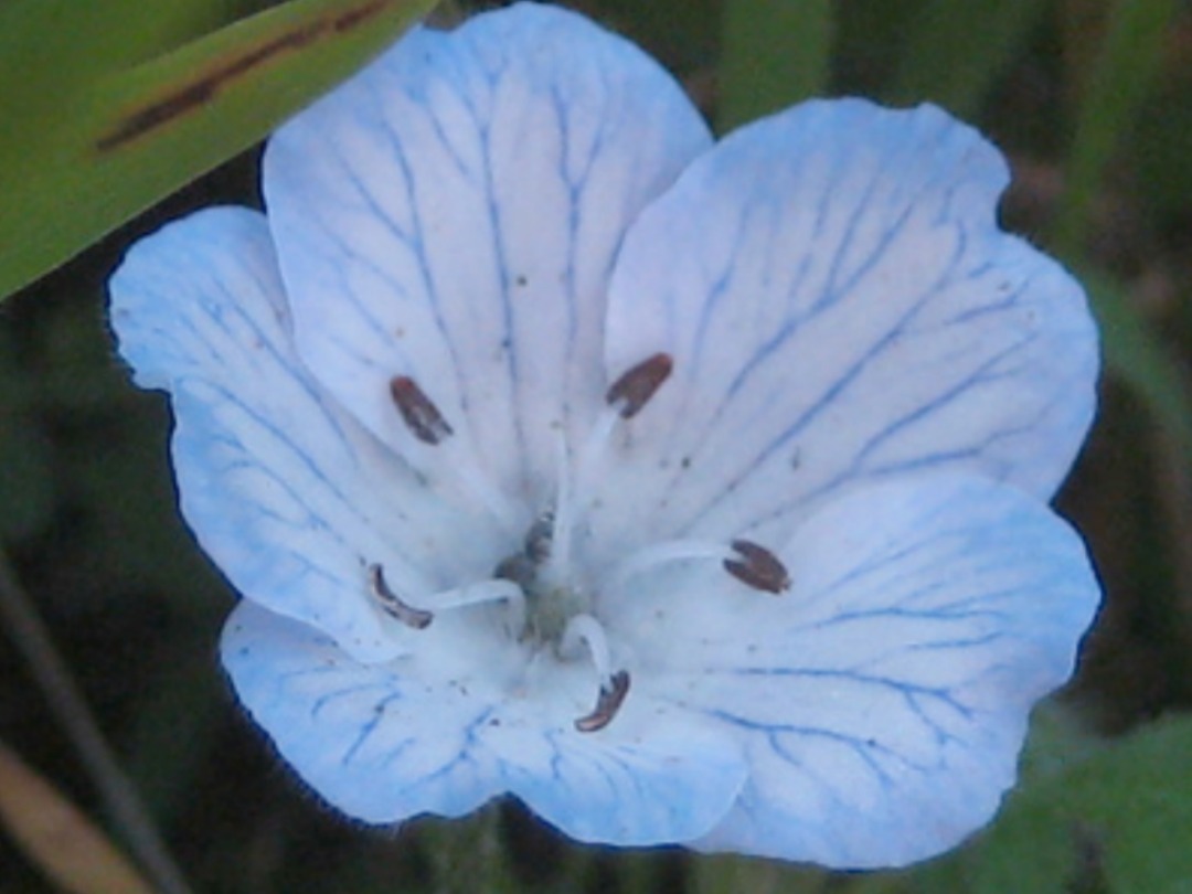
Wildflower Guides:
Other Activities

Rock climbing: Mt. Tamalpais has four slabs for climbing, ranging from 25’ to 45’ at East Peak. Most people use a top rope, but you can also do a traditional climb on the northern formation. Please visit the Mountain Project website for more information.
Geocaching: Geocaching is a form of treasure hunting using a GPS receiver and a map to locate treasure caches throughout the globe. There are hundreds of caches in northern California alone. Please visit the official Geoching website for more information.