Hiking
Self-Guided Loop Hike Recommendations
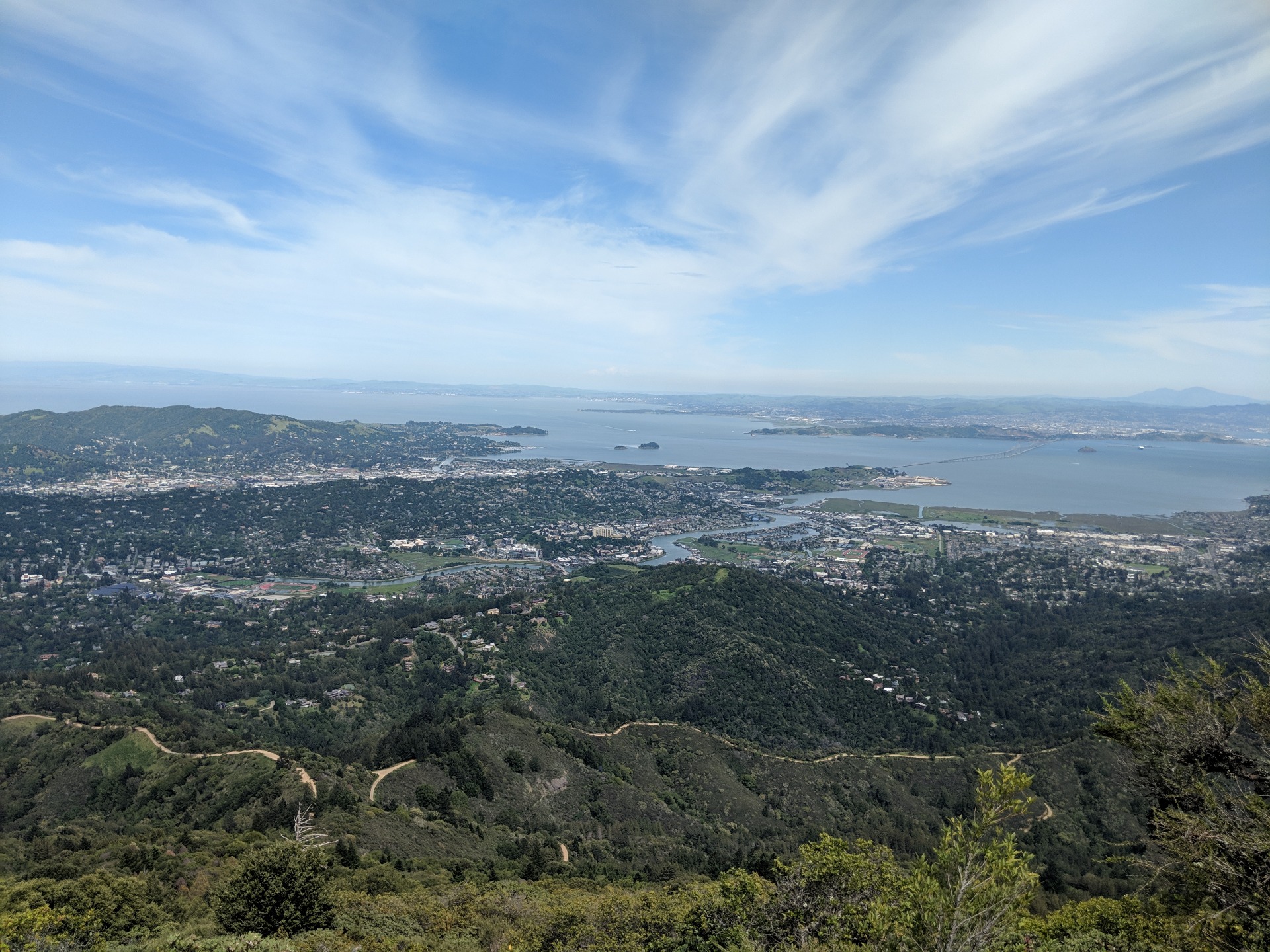
Click on any of our brochures below for more informationRedwood forests, open grasslands, oak woodlands, ocean views, you name it. There are several hundred miles of trails in the State Park and adjacent areas such as the Marin Municipal Water District for you to explore. While you are welcome to join any of Friends of Mt Tam guided hikes (see below section), you may wish to hike on your own.
Because there are so many trails on Mt Tamalpais, we strongly recommend you bring a map with you.
- Get directions and download a detailed State Park PDF map here. (It’s a big map.)
- State Park maps are free at either the Pantoll Ranger Station or the East Peak Visitor Center.
- Click here for a Google Map of trailheads and trailhead descriptions.
Pantoll Quad Challenge
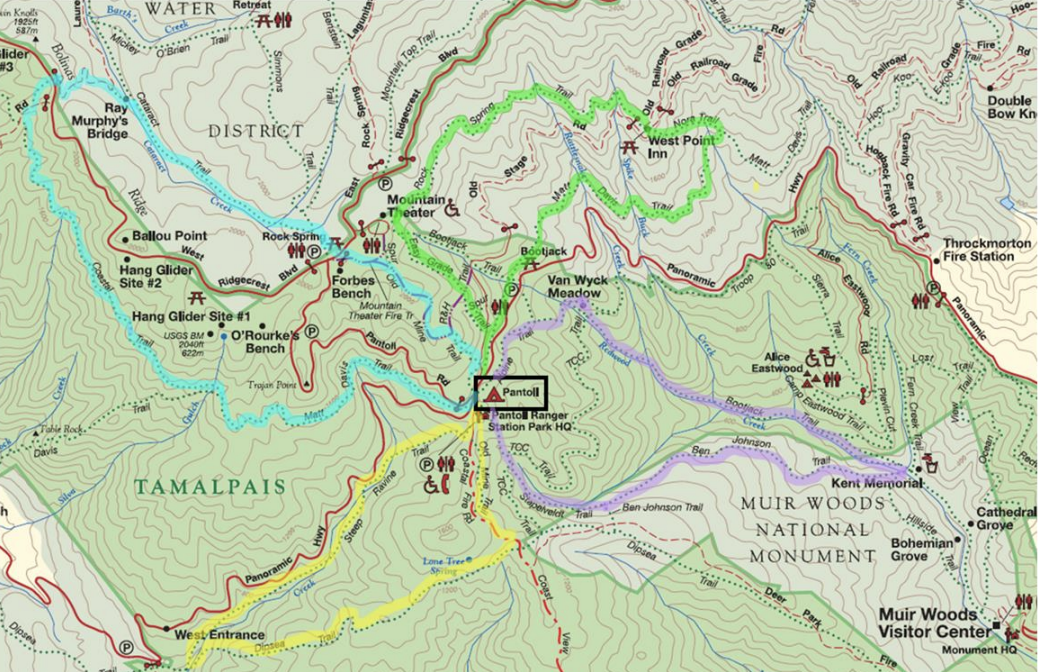
Four Epic Hikes that Start/End at Pantoll
21 miles & 4,300 feet of elevation
HOW IT WORKS
✓ Complete all 4 hikes
✓ Email FriendsOfMtTam@gmail.com with:
▪ Your name & mailing address
▪ What you liked about each hike
✓ FMT will send you a “I HIKED THE PANTOLL QUAD” commemorative badge
Other Hikes and Brochures

Bootjack Loop Hikes
Four hikes: 1.4 miles, 3.6 miles, 5.0 miles, 6.9 miles
Pantoll Loop Hikes
Six hikes: 2.0 miles, 2.5 miles, 3.8 miles, 4.7 miles, 6.0 miles, 7.0 miles
Rock Spring Loop Hikes
Four hikes: 2.0 miles, 3.0 miles, 4.6 miles, 6.0 miles

East Peak Loop Hikes
Four hikes: 2.2 miles, 4.2 miles, 5.0 miles, 7.0 miles
Verna Dunshee Loop Walk
East Peak Verna Dunshee Loop Walk Brochure
Fire Lookout Plank Walk
East Peak Plan Walk/Gardner Fire Lookout Brochure

Davis-Eastwood Brochure
Information about the Matt Davis and Alice Eastwood
CCC on Tam Brochure
History of the Civilian Conservation Corps on Mt Tam Brochure
Guided Hike Information
- Hikes vary in difficulty, please see the description or contact us for more information.
-
Due to traffic conditions the morning of the hike, or a last minute illness of the hike leader, hikes can be cancelled at the last minute. We also strongly recommend carpooling and arriving 15min early to find parking. Remember that certain parking areas require a fee (Pantoll, Bootjack – cash-only, East Peak – cash only).
- For detailed information on what to bring and be aware of, especially for your first hike on Mt. Tam, please read our Guided Hike Tips.
- Check the State Park Events Page for a list of all events happening at the park.
| DIFFICULTY RATING | DESCRIPTION |
|---|---|
| E = Easy Hikes | Slower paced hike 3.5 to 5 miles with under a 1000′, elevation gain. For beginning hikers, senior hikers, and in-betweeners. |
| M = Moderate Hikes | Moderately paced, about 5 to 7 miles with up to 1500′ elevation gain. |
| D = Difficult Hikes | 7+ miles, over hilly, rocky terrain, 2000’+ elevation gain and are quick paced. |
FMT Guided Hike Tips
WATER
Bring at least THREE bottles of water on hot days. Most hikes do not pass by public drinking water sources.
FIRST AID
Carry minimal first-aid supplies (e.g. band-aids and simple blister remedies).
HIKING TIME
The exact time the hike will end cannot be predicted due to differences in the pace each group moves and conditions out on the trails. For Saturday hikes, groups usually return before 2:30 PM. The average hiker can hike about 2mph with minimal elevation gain.
Remember to give yourself time to drive down the mountain and take traffic into consideration.
FOOD
Weekend hikes stop for lunch; a light sandwich and fruit are good to bring.
Wednesday evening hikes stop for a snack.
PROTECTION
Protect yourself, wear a wide brim hat and sunscreen – the hike may spend the day out in full sun.
Ticks, mosquitoes, horse flies and yellow jackets are present, but not abundant.
STURDY BOOTS
Your most important gear. The trails are uneven, rocky and very steep in places. To provide stable footing, mid-height (or higher) with lugged soles and plenty of tread are highly recommended.
Sandals, sneakers and running shoes are not recommended.
Hiking poles are recommended.
FLASHLIGHT
Nice to have for Wednesday evening and/or moonlight hikes.
CELL PHONE
Bring it but be aware there are areas without service on the mountain.
It is a good idea to share your cell phone number with the hike leader. Being able to communicate before the hike on rainy days and fire danger days or if separated can be helpful.
MAP/COMPASS/GPS
A map, like the 10th edition of the Olmsted map of the Mt. Tamalpais area hiking trials, and/or a guide book such as “Tamalpais Trails” by Barry Spitz, are excellent ways to increase your familiarity with Mt. Tam trails.
A guided hike is a good time to practice hands-on use of the trail map and navigation devices, although you can depend on the hike docent to lead the way.
Become a Hike Leader!
Interested in leading hikes on Mt. Tam? Sign up to volunteer as a hike leader for Mt. Tam State Park!